|
|
||
|
|
|
|
|
||||||||
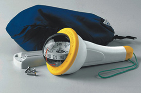
Using a Hand-Bearing CompassGetting a fix and more! A coastal sailor's favorite weapon.Have you ever wondered whether a hand-bearing compass is really useful or just another toy that spends its life tucked safely inside a locker with all those other impulse buys? Might you not be able to accomplish the same things with a binnacle mounted compass? The answer to the second question is simply, “No", unless you point your boat exactly at the mark you are attempting to get a bearing on. The answer to the first question is one only you can arrive at. I can tell you for certain that for us it is one of the most valuable, often unbreakable, non-electronic (therefore not susceptible to electrical failures) low-tech tools in our armamentarium. But don’t listen to us. Decide for yourself with some simple (and maybe not so simple) ways to apply your compass. Hand-bearing compasses enable you to take a magnetic bearing on a distant object. This bearing allows you to plot lines of position for coastal navigation. You can also check to see if a collision is probable, if your anchor is dragging, and how far off shore you are at any given time. Racing sailors can check position relative to their competitors by seeing if the bearing to a competitor changes over time.
Fixing your positionWhen two or more fixed charted features are visible and identifiable, a hand-bearing compass makes it easy to determine your exact location. Suppose there is a lighthouse visible to the west of you and the stacks of a power plant visible to the south. First, take a bearing on the lighthouse, then plot that bearing with a line running through the charted location of the lighthouse. Next, take a second bearing on the stacks, and plot that line on your chart. Your exact location is where those lines, called lines of position or LOP, intersect. Some notes of caution. Do not use water based aids to navigation (ATONs) as they can be off station. Use only land based stationary objects. Also, make sure that the angle between the two objects is as wide as possible. Two objects less than 90 degrees apart do not offer enough distinction to be trustworthy. You don't always need two bearings to determine your position. Say you have plotted the bearing to the lighthouse, but fog obscures the power plant. You might use your depth sounder for assistance. Let’s say it reads 50 feet. Your location might be isolated as being where your bearing line crosses the 50-foot contour line on the chart. Or you can do running fixes, that is, take bearings on the same object at different points in time. If you use your trusty formula for speed, distance and time, you can get a fix on your position. Avoiding collisionIn a crossing situation you can determine very easily if there is any risk of collision by keeping track of the relative bearing of the other boat. This is an easy check with a hand-bearing compass. Let's say the other vessel is a container ship. As soon as you see it, you get a bearing on it with your hand-bearing compass. A few minutes later you take another bearing. If the reading has changed substantially, the ship will pass safely by, either ahead or astern, assuming both vessels maintain current course and speed. If the bearing doesn't change, you are on a collision course, no matter what direction your bow is pointed in and you’d better take evasive maneuvers. Although beyond the scope of this article, download a pdf of a very useful tool for tracking relative positions – The Universal Plotting Sheet. Determining distance offThis is an especially useful technique for coastal sailors. Let’s say that according to the chart there is a shallow area that extends out from the coastal shoreline a mile and it’s somewhere ahead of you. How can you tell if you are far enough offshore to avoid the shallows (other than using GPS of course)? Using a hand-bearing compass as you pass a distinct shoreline feature, you can estimate the distance off in miles by noting how much time it takes your bearing to change by the same number of degrees as your boat speed. Say that again, please? Let’s try it this way. You are sailing along at 6 knots so are going to measure the time it takes for your boat to travel through a 6° bearing change. When the shoreline feature you are using (the lighthouse again especially at night) is about half your speed in degrees ahead of the beam, i.e., about 3° ahead of the beam, you start timing your run. Let's assume that your heading is due south (180°) so the marker will bear 270° as it passes abeam on your starboard side. When it bears 267° you note the time, noting it again when the marker bears 273°. If it took four minutes and 30 seconds for the bearing to change 6° while running 6 knots your distance from the marker when it was abeam was 4.5 miles, the same as the time in minutes. By the way, knowing you are 4.5 miles off gives you one line of position – just draw a line parallel to the coast at 4.5 miles. A bearing on the shoreline feature gives you a second line of position. Where they cross is where you are. Determining if you are dragging anchorYou reach your destination, a quiet anchorage, where you carefully lower the anchor. The breeze is barely making a ripple. You are set for the night, unless the wind picks up and/or a shift in current causes your anchor to drag. You have set the anchor alarm on your GPS or Loran to alert you if something goes wrong. But you know that Loran signals may drift a bit at dusk and dawn and GPS can be equally unreliable under some circumstances, including proximity to strong TV signals and the occasional government exercise. For the sake of safety and peace of mind, you take a round of sights on distinctive objects that are likely to be visible in the darkest times on the shore with your trusty hand-held compass, noting also the bearing to the fastest escape routes and safest re-anchoring spots. Now if the alarm goes off, you'll not only be able to verify whether your anchor is dragging, but you will also have a plan of action to take safely if it is. Taking a bearing
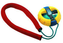
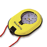
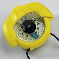
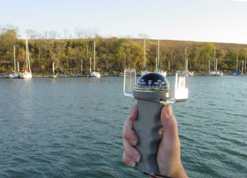
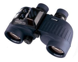
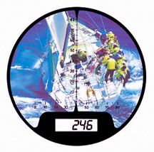
To use an arm's-length compass (usually with a pistol grip), put the lanyard around your neck to stabilize the unit. Hold the compass at eye level, then line up the V-notches in the sighting vanes on the top of the compass with the desired object; now check the bearing by glancing at the compass card. It can be tough to keep compass and sights lined up and checking some small numbers all at the same time, especially on a moving boat in the dark. A hockey puck style compass with an infinity prism that is held up to your cheek lets you sight across the top of the small prism. When you are focusing on the object in the distance, the prism projects the bearing into your field of vision so you don't have to shift your eyes. Object and bearing are in focus at the same time, which is a tremendous asset for taking accurate bearings in rough conditions. Operating a digital compass is very much like taking a snapshot. You use the unit's aiming system to take the sight, then press a button. It couldn't be easier. High end binoculars have the compass built right in and offer night lighting. You focus on your object and read the bearing from the same place.
|
 |
 |
We’ve also supplemented our hand bearing compass with binoculars that have a compass built in. I must admit, that I am now spoiled. Being able to pick out coastal marks day or night and take a direct bearing without taking my eyes off the object has simplified navigation tremendously. Nevertheless, I always keep my trusty hand bearing compass in the pocket of my foul weather gear. That way I know it’s with me whatever boat I am on.
For a more complete understanding of navigation, we recommend taking the USCG Auxiliary course, Advanced Coastal Navigation. This is offered multiple times a year in major metropolitan areas, often through the local adult school programs. There are also many useful books on navigation techniques but without the ability to ask questions, you may not get the full benefit. Once you do learn useful techniques like this, we urge you to practice them routinely whether or not you use sophisticated electronics. We’ve learned by default (and error) that the day you experience battery failure offshore is not the day to ask, “Now what was that thing about hand bearing compasses and LOPs?”
|
Europe: Port Aleria, Rosnakilly, Kilmeena, Westport, Co. Mayo, Ireland - USA: PO Box 726, Mahwah, NJ 07430 All content on this site is subject to Copyright© - All rights reserved. Contact us - Advertising - Privacy - Terms & Conditions - Copyright & Trademark - Webmaster |