A comparison of two of our favorite Cruising Grounds in the East Coast of the USA
Facts about Chesapeake Bay
(from the
Chesapeake Bay
Foundation)
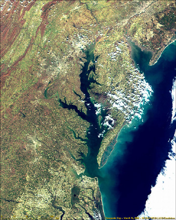
Chesapeake Bay
satellite image and watershed projection. From NASA Visible Earth and CBF website.
 |
- 200 miles long and runs North to South. It is
North America
's largest estuary (an area where fresh and salt water mix), emptying into the
Atlantic Ocean
in
Virginia
. The
C&D
Canal
connects it with
Delaware Bay
at the northern end.
- More than 11,600 miles of shoreline bordered by three states (DE, MD, VA), more than the entire West coast of the
United States
. The vast majority is privately owned.
- Watershed covers 64,000 square miles and encompasses parts of six states:
Delaware
,
Maryland
,
New York
,
Pennsylvania
,
Virginia
, and
West Virginia
as well as the
District of Columbia
.
- More than 150 major rivers run through the broad
Chesapeake
watershed; the
Susquehanna River
provides about 50% of the freshwater coming into the Bay - an average of 19 million gallons of water per minute. About 10,000 smaller tributaries drain into those rivers.
- The current population within the watershed numbers about 16 million (compared to 3 million a century ago) and is expected to increase to more than 18 million by 2020.
- The water is surprisingly shallow with an average depth of 21 feet yet holds more than 18 trillion gallons of water. Anyone six feet tall could wade through over 700,000 acres of the Bay. There are a few deep troughs running along much of its length, including "The Hole" located off
Bloody Point
,
MD
that is 174 feet deep.
- The Bay's salinity ranges from freshwater (0-0.5 parts per thousand or ppt) near the
Susquehanna River
to water of nearly oceanic salinity (30-35 ppt) at the
Chesapeake
's mouth.
- Narrowest part of the Bay is 3.4 miles at
Aberdeen
,
Maryland
and the widest point is near the mouth of the
Potomac River
– 35 miles.
- 450,000 boats registered in MD/VA in 2003
- Two of the five major
North Atlantic
ports in the
United States
(Baltimore and Hampton Roads).
- Watershed supports more 3,600 species of plant and animal life, including 348 species of finfish, 173 species of shellfish and over 2,700 plant species. The
Chesapeake
is home to 29 species of waterfowl and is a major resting ground along the Atlantic Migratory Bird Flyway. Every year, one million waterfowl winter in the Bay's basin.
- Produces 500 million pounds of seafood per year.
- Formed about 12,000 years ago when glaciers melted and flooded the
Susquehanna River
valley. The archeological record shows that humans have inhabited the watershed since 8,000 B.C. Mammoth, mastodon, bison, elk, camel, horse, and peccary roamed the
Chesapeake
watershed during this era. The name
Chesapeake
is derived from the Native American word "Tschiswapeki" meaning "great shell fish bay." The
Chesapeake
was the first in the nation to be targeted for restoration as an integrated watershed and ecosystem.
Facts about Long Island Sound
(from The Long Island Sound Study, 1996, Haddam, Stony Brook and EPA website)
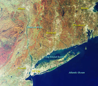
Long Island Sound from
New York City
to the Rhode Island Border, and drainage basin.
 |
- 110 miles long running West to East (unusual among estuaries), unlike most estuaries open at both ends -- through the Race at the eastern end to the Atlantic Ocean and through the East River and New York Harbor at the western end.
- 600 miles of shoreline (including 90 miles from the islands) encompassing an area of 1320 square miles bordered by 2 states (NY & CT). Includes 248 miles of beaches, 95 miles publicly owned.
- Drainage basin or watershed covers 16,820 square miles and extends into
Canada
; 5 states contribute to the Sound’s watershed (Ct, MA, NH, NY, VT).
- 5 million people live along its coast, 14.6 million people live within its drainage basin and 20 million people live within 50 miles; it is the most densely populated region in the
United States
.
- Average depth is 78 feet, and the deepest point is approximately 300 feet and is located at the Eastern end.
- 21 miles at its widest point
- 90% of its freshwater comes from the
Connecticut
,
Thames
, and
Housatonic
Rivers
. Salinity ranges from 23 ppt (western end) to 33 ppt (at the Race) and surface temperatures range between 32-73 degrees fahrenheit.
- Two high tides and two low tides each day. Tides greatest at western end. Currents strongest at eastern end.
- Encompasses volume of 18 trillion gallons or 67 billion tons
- 44 sewage treatment plants discharging directly into the Sound.
- Fish Populations: more than 120 species of finfish, including 21 tropical species that stray here seasonally; at least 50 species spawn in the Sound
- Commercial fisheries worth $36-$40 million to the economy in 1987. Estimated total value to the local economy: $5.5 billion per year
- 750,000 recreational fishermen; sport fisheries worth $70-$130 million to the economy in 1987.
- 20,000 boat slips and 200,000 boats registered “Sound-wide.”
- Long Island Sound occupies lowland that was initially carved into the coastal-plain by rivers, and subsequently glacially modified. The combined erosive effects of the ice advances included re-exposing, wearing down and smoothing the crystalline Appalachian rocks that now form the Connecticut coast, cutting back and sculpting the remaining coastal plain wedge (which now forms the foundation of Long Island), and redistributing eroded material in the form of glacial deposits known as terminal moraines along the middle of Long Island. As it receded about 20,000 years ago, the glacier left a pile of debris known as a recessional moraine that formed freshwater
Lake
Connecticut
, This eventually drained out to the sea through an outlet at the Race. The bulk of the above-water portions of
Fishers Island
,
Plum
Island
, northernmost
Long Island
, the
Thimble
Islands
as well as the Captain and
Norwalk
Islands
are parts of the recessional moraine. Sea-level rose continuously relative to the land filling in the lake and forming the Sound about 5000 years ago. (Ralph Lewis, Geologist, UConn)
|
